

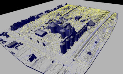
Topographical mapping documents site features such as buildings, structures, above-ground utilities, terrain and landforms into a 3D digital map.
Courtesy of ScanStar LLC
When it comes to the construction or modification of a grain processing or animal feed mill operation, technology is revolutionizing the way we engineer and plan these projects.
When existing conditions of sites are scanned, millions of data points from the surfaces of the objects are captured resulting in an accurate point cloud of the scanned areas.Courtesy of TruePoint Scanning


.jpg?auto=format%2Ccompress&fit=crop&h=167&q=70&w=250)


